Are you interested in knowing what our Earth looks like from space? You might be guessing how it is possible as the Earth is so large! But there is a solution to this.
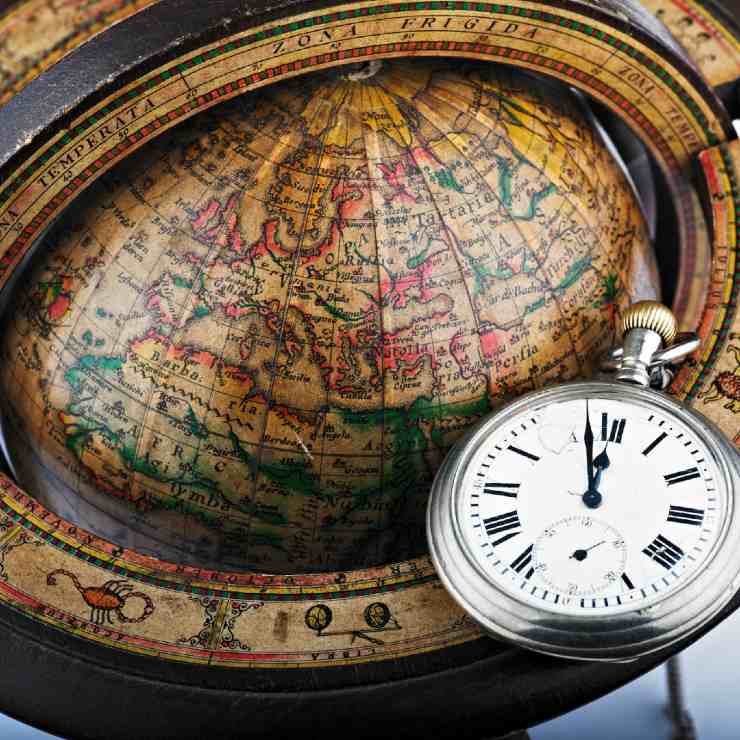
A globe is a way by which we can see the complete Earth at once. It is a real-life model of our Earth which is a 3D sphere. The globe of the Earth is also called a terrestrial globe. Globes are available in different sizes and types from pocket-size globes to large balloon-like globes.
Features of a globe:-
- A Globe shows all the continents and oceans of the planet in the correct size based on a scale.
- It is not fixed and is rotatable along a needle that is fixed through it in a tilted manner which represents the axis.
- The two points through which the axis passes are called the Poles. They are named the North Pole and the South Pole.
- The globe moves around the axis in the west to east direction same as the Earth does. But the real Earth doesn’t have any such needle. The real axis is just an imaginary line.
- It also has several vertical and horizontal lines on it. These are called the Longitudes and Latitudes.
What are Latitudes?
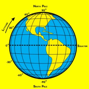
Latitudes are the horizontal lines marked on the map or a globe. These lines are imaginary. While they run from east to west, they indicate the north-south position on the earth. The value of latitudes ranges from 0o at the equator to 90o at the Poles. Higher the value of latitude, the closer it is to the North or South Pole.
1. Equator:–
It is one of the most important latitudes. It is the imaginary line dividing the Earth into two halves. The portion above the Equator is the Northern Hemisphere while the portion below the Equator is the Southern Hemisphere. It is important for the location of places on Earth. It represents the 0o latitude and is 40,075 kilometers long. All the lines below and above the Equator are known as Parallels of Latitudes. With the help of these parallels, the value of latitudes is followed by N or S representing the hemisphere. The parallels are measured in degrees followed by N or S. For example 40o N or 40o S.
2. Tropic of Cancer:–
It is located in the Northern Hemisphere at 23o N
3. Tropic of Capricorn:–
It is situated in the Southern Hemisphere at 23o S.
4. Arctic Circle:–
It is located at 66.5o to the north of the equator
5. Antarctic Circle:–
It is located at 66.5o to the south of the equator
Different Heat Zones
The Earth is divided into three Heat Zones based on the amount and angle of sunrays received.
- The Torrid Zones All the latitudes between the Tropic of Cancer and Tropic of Capricorn receive sun rays at least once a year. Thus, this area receives the maximum amount of heat and is called the Torrid Zone.
- The Temperate Zones The areas between the Tropic of Capricorn and Antarctic Circle in the Southern Hemisphere and between the Tropic of Cancer and Arctic Circle in the Northern hemisphere receive fewer sun rays and have moderate temperatures. This is because the angle of sun rays keeps on decreasing as we move towards the Poles. These regions are called Temperate Zones.
- The Frigid Zones The areas between the North Pole and Arctic Circle and between the South Pole and Antarctic Circle are Frigid Zones. The temperatures in these zones are very less as the sun rays are slanting and less heat reaches here. These areas either are very cold or remain frozen completely.
What are Longitudes?
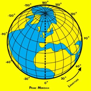
Latitudes themselves are not enough for locating places on the planets. Longitudes are the vertical lines running in the North-South direction and they mark the east-west position of the place. These are also commonly called meridians of longitudes.
These lines run from pole to pole and cross the equator at right angles. All longitudes are equal in length. Each degree is divided into minutes and seconds. The 0-degree longitude is known as the Prime Meridian which divides the Earth into Eastern and Western Hemisphere. The count of meridians starts from Greenwich where the Prime Meridian is located.
From the Prime Meridian, we can count 180o east and west of it. The longitudes are denoted by degree followed by E or W representing East or West. Interesting thing is that 180o E and 180o W are on the same line.
With both Longitudinal and Latitudinal points, one can locate any point or place in the world.
How is time detected?
In ancient times, time was detected with the help of solar clocks. They worked on the principle of sunrays received by them. Local time of a place can be easily detected by the shadow cast by the Sun as it is shortest during noon and longest at sunrise and sunset.There was a need for an international time standard for reducing confusion, with the growth of communication and travel across the world.
When the Sun is at the highest position at the Prime Meridian in Greenwich, all places along it will have noon. The Earth rotates from west to east. So the places that are east of Greenwich will be ahead of Greenwich Time and the places west to it.
The difference in time is calculated in the following way.
- The earth rotates a complete 360o in 24 hours, which is 15o in one hour or 1o in 4 minutes.
- So, at noon in Greenwich, a place that is 20o east of Greenwich will be 20*4=80 minutes or 1 hour 20 minutes ahead of Greenwich or the time there would be 1:20 pm.
- Similarly, 20o west of Greenwich will have a time of 10.40 am.
- Same way, at 180o to Greenwich, it will be midnight.
The time shown by any watch will be the local time of that place. A watch at any place can be adjusted to show 12 when the sun is directly up or it is noon. This mean places on the same longitude will have the same local time.
What is India’s Standard Time and why is it important?
It is important to adopt the local time of a central meridian of a country as the standard time for uniformity as the times on different meridians are different. For example, there is a difference of 1 hour 45 minutes in the local times of Dwarka in Gujarat and Dibrugarh in Assam.
India has adopted the longitude of 82o30’ east of Greenwich as the standard meridian and the local time at that meridian is considered as the Indian Standard Time for the country. It is commonly called IST. The IST is 5 hours and 30 minutes ahead of the Greenwich Meridian Time. So, when it is 3:00 pm in Greenwich, it is 8:30 pm in India.
Countries with larger size have adopted more than one standard time such as Russia, which has eleven standard times.
Did you know?
- The Earth’s diameter is wider at the Equator, which is called the equatorial bulge.
- The system of latitudes and longitudes was thought of by Eratosthenes in the 3rd century.
- The speed of rotation of Earth is slower at the Arctic Circle than the Tropic of Cancer due to its larger size. Similarly, it is slower at Tropic of Cancer than at the Equator.
- The Sun, Moon, planets and stars rise from the east and set in the west. This is simply because Earth spins towards the east.
- People living at or near the Equator are continuously moving at a speed of 1600 kilometres per hour.